| Boundary Channel | |
|---|---|
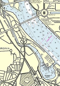
 Map of area surrounding Boundary Channel and the Pentagon Lagoon | |
| Location | |
| Country | United States |
| State | District of Columbia |
| Physical characteristics | |
| Source | Potomac River |
| • coordinates | 38°53′24.4″N 77°3′49.3″W / 38.890111°N 77.063694°W |
| • elevation | 0 ft (0 m) |
| Mouth | Pentagon Lagoon |
• coordinates | 38°52′26″N 77°2′53″W / 38.87389°N 77.04806°W |
• elevation | 0 ft (0 m) |
| Basin features | |
| River system | Potomac River |
Boundary Channel is a channel off the Potomac River in Washington, D.C. The channel begins at the northwestern tip of Columbia Island extends southward between Columbia Island and the Virginia shoreline. It curves around the southern tip of Columbia Island before heading northeast to exit into the Potomac River. At the southwestern tip of Columbia Island, the Boundary Channel widens into the manmade Pentagon Lagoon.
© MMXXIII Rich X Search. We shall prevail. All rights reserved. Rich X Search
